4. ASSESSING HISTORICAL CHANGES
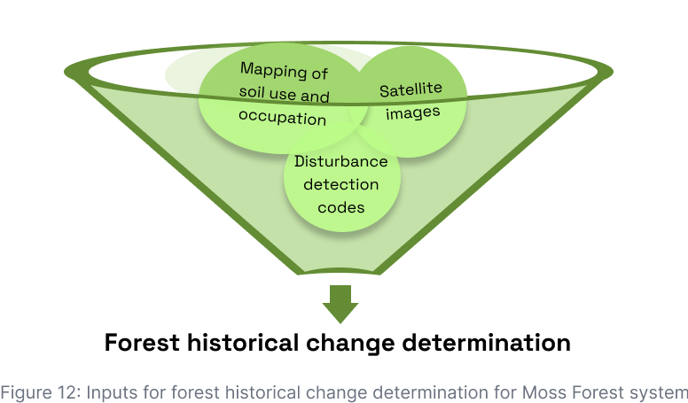
Moss Forest assesses historical land use and forest changes via a tool that includes the inputs shown in Figure 12. This tool’s objective is 1) to identify the forest areas converted into non-forest areas and the associated changes in carbon stocks; 2) forest areas that have suffered loss of carbon stocks through degradation activities and changes in carbon stocks; 3) forest areas in the process of gaining carbon stock from enhancement activities and associated changes in carbon stocks.
The Moss Forest system automatically queries providers of open-source data, according to the frequency of availability of information for each one and superimposed with the rural properties registered in Moss Forest. If deforestation or fire alerts are identified in any monitored area, they are immediately communicated in the management and communication system of the Moss.Earth monitoring team, expediting the inspection process in loco and communications to stakeholders.
The deforestation and fire alerts consulted are obtained from the Project for Monitoring Deforestation in the Legal Amazon by Satellite (PRODES), the Monitoring Program for Burns and Forest Fires of the National Institute for Space Research (INPE) and the Radar for Detecting Deforestation (RADD Alerts).
4.1. MapBiomas Alert
MapBiomas Alert - http://alerta.mapbiomas.org/ - is a system for validating and refining native vegetation deforestation alerts in all Brazilian biomes using high-resolution images. It is the result of a partnership between government user agencies (e.g., MMA, IBAMA, SFB, ICMBio, MPF and TCU) and providers and their alert-generating systems (e.g., DETER/INPE, SAD/IMAZON, GLAD/Maryland University, ISA).
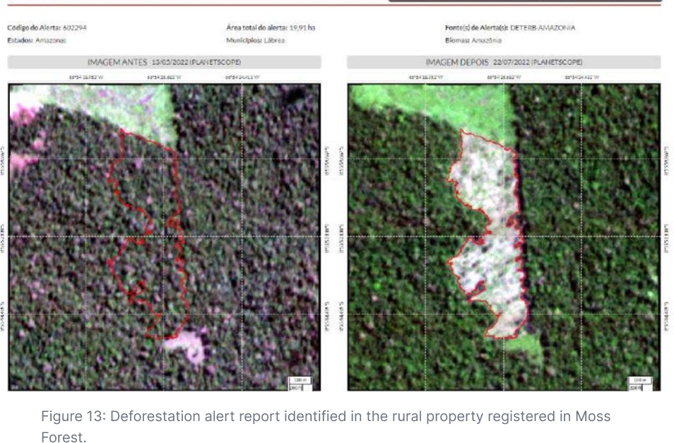
Moss Forest consults automatically the MapBiomas code and superimposes its alerts on properties registered in Moss Forest. Such alerts have a minimum area of 0.3 hectares and are validated by visual inspection by MapBiomas and, subsequently, for each alert, high-resolution images, one from a date before and another from a day after the deforestation, are selected. The Moss Forest system uses “Planet” images (daily pass, 3.5 meters of spatial resolution) or “Sentinel-2” images (weekly pass, 10 meters of resolution). The Moss Forest system refines the boundary using machine learning algorithms and cloud processing on the Google Earth Engine platform.
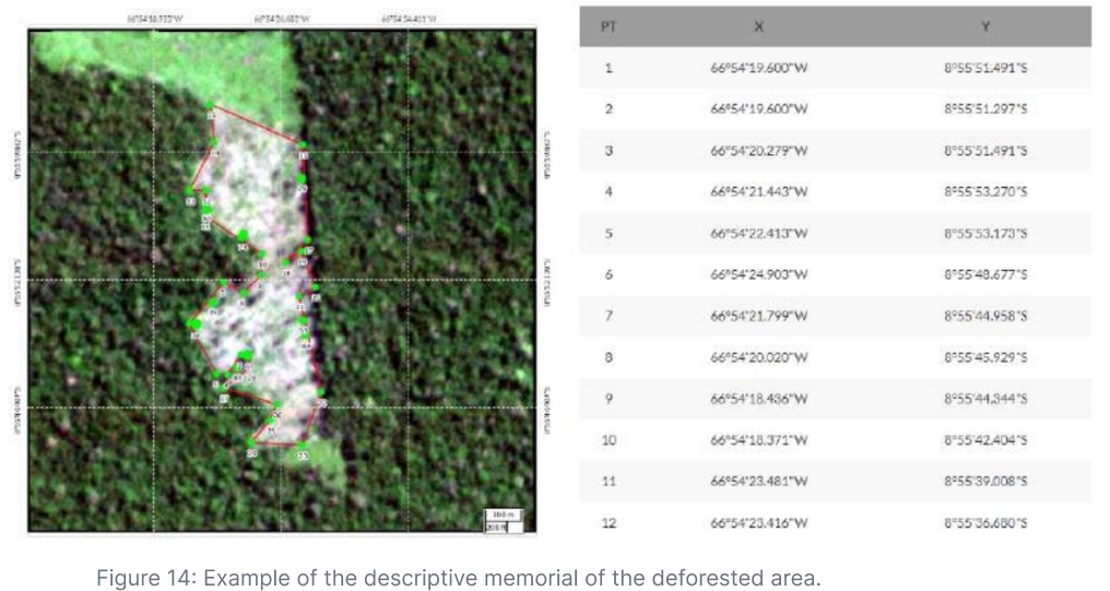
Using this system, Moss Forest obtains the deforestation alert vectorial polygons and the respective deforestation reports (Figure 13) from the descriptive memorandum of the deforested area (Figure 14). The report also informs the pressure vector detected for the alert area and if there is any overlap between the deforested polygon and also the areas legally deforested by IBAMA or by governments in the states of Mato Grosso and Pará. For the rest of the states in the Legal Amazon, there is not yet geographic data available on authorizations for alternative use and vegetation suppression.
4.2. INPE
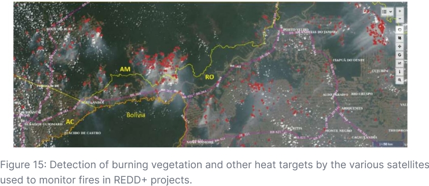
The “Fire Alert Program” of the “National Institute for Space Research” (INPE) carries out research, technological development and the innovation of products, processes and geoservices for monitoring and modeling the occurrence and propagation and classification of active fire in vegetation, its risk, extent and severity, using Remote Sensing, Geoprocessing and Numerical Modeling techniques.
The Program uses near-real-time (24-hour) heat spot detection algorithms from various satellite imagery sources (Terra, Aqua, Suomi NPP, NOAA-15, NOAA-18, NOAA-19, Metop-B, GOES-16 and Meteosat-10 MSG-3). The existence of a heat spot is a reliable indicator of the occurrence of fire and its rapid detection, often allowed by the use of this range of images and fire detection data, increases the level of monitoring and prevention of the advance of fire fronts in REDD+ project areas.
Below (Figure 15), it is possible to observe the detection of burning vegetation and other heat targets by the various satellites used to monitor fires in Moss Forest's REDD+ projects.
4.3. RADD Alert
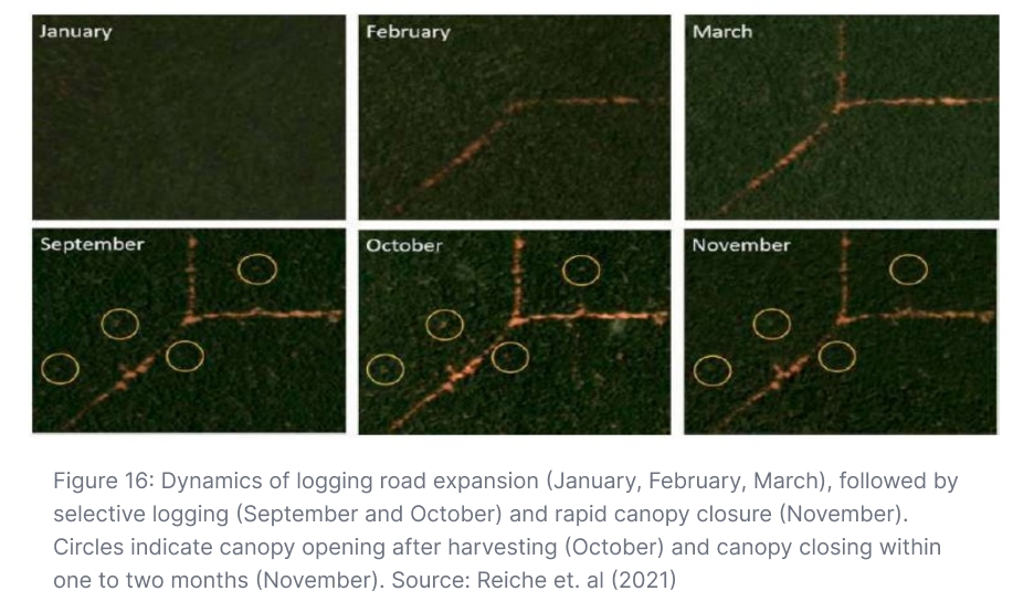
The Moss Forest for Brazilian forests uses the radar alert code RADD (RAdar for Detecting Deforestation), an initiative by the University of Wageningen, in collaboration with the World Resources Institute's Global Forest Watch program, Google, the European Space Agency and the University of Maryland and Deltares. The alert system based on the Sentinel-1 satellite is implemented in Google Earth Engine - https://nrtwur.users.earthengine.app/view/raddalert - to map new disturbances in the forest. With visits to areas every 6-12 days and satellite image resolution of 10 m, this system uses a detection algorithm (Figure 17) that identifies forest disturbances in near-real time, defined as the complete or partial removal of tree cover within a 10m x 10m (0.01ha) pixel.
Complete removal of tree cover is associated with disturbance from stand replacement at the Sentinel-1 pixel scale, while partial removal mainly represents disturbances associated with contour pixels and selective logging - www.wur.nl/en/research-results/chair-groups/environmental-sciences/laboratory-of -geo-information-science-and-remote-sensing/research/sensing-measuring/radd-f orest-disturbance-alert.htm . In our opinion, this is a superior system to those currently in use, which are predominantly dependent on satellite data with an average resolution of 30–100 m and with long time intervals between visits to the areas. With RADD alerts, even small disturbances are detected in the forest by selective cutting, often preceding the clear cutting and not detected by other satellites due to the rapid forest regeneration and the slow revisiting of the satellite in that same location; these dynamics are observed in Figure 16.
Using RADD, properties registered in Moss Forest are monitored consistently and routinely and any detection of deforestation or illegal logging can be better monitored (Figure 17).
Last updated